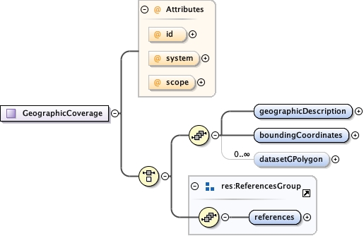
<xs:complexType name="GeographicCoverage">
  <xs:annotation>
    <xs:documentation>tooltip: Geographic coverage summary: Geographic coverage information. description: Geographic Coverage is a container for spatial information about a a project, a resource, or an entity within a resource. It is meant for general information and not for accurate mapping. More specific information, including mapping projections, is covered by EML in the spatialReference schema.</xs:documentation>
  </xs:annotation>
  <xs:choice>
    <xs:sequence>
      <xs:element name="geographicDescription" type="res:NonEmptyStringType">
        <xs:annotation>
          <xs:documentation>tooltip: Description of geographic extent summary: Short text description of the geographic areal domain of the data set. description: geographicDescription is a short text description of a dataset's geographic areal domain. A text description is especially important to provide a geographic setting when the extent of the data set cannot be well described by the "boundingCoordinates", or in the case of data which are not specifically geospatial. Assuming the "boundingCoordinates" do not adequately describe the extent of the data set, the discrepancy can be identified and described here. The coordinates may define a rectangle around a country, with this geographicDescription element containing a disclaimer and/or further details concerning the border. A study of the diseases of salmon may not have a specific geographic extent associated with it, but the salmon were collected in the states of Washington and Oregon. The "boundingCoordinates" might form a general rectangle around the states of Washington and Oregon, but the "geographicDescription" might describe the fact that the study took place only along certain rivers within those states. This data element differs from the standard data element "Place_Keyword" in that it allows a free text description of the geographic extent, rather than just a list of words or phrases useful as an index of location names associated with the data set. This element can also contain information about the collection of the boundingCoordinates, e.g., an altitude value that is referenced to Mean Lower Low Water, or the projection system that the latitude and longitude coordinates were taken from.</xs:documentation>
        </xs:annotation>
      </xs:element>
      <xs:element name="boundingCoordinates">
        <xs:annotation>
          <xs:documentation>tooltip: Bounding coordinates summary: The four margins (N, S, E, W) of a bounding box on the earth's surface, or when considered in lat-lon pairs, the corners of the box. To define a single point, use the same value in each lat or lon pair. These elements are meant to convey general information and are not for accurate mapping. More specific information may be included by using the elements in the spatialReference schema. description: Bounding Coordinates are the four margins (N, S, E, W) of a bounding box, or when considered in lat-lon pairs, the corners of the box. These elements are meant to convey general information and are not for accurate mapping. More specific information may be included by using the elements in the spatialReference schema. The limits of coverage of a data set should be expressed as decimal latitudes and longitudes, and in the order western-most, eastern-most, northern-most, and southern-most. By convention, latitudes and longitudes are referenced to the Equator and to the Prime Meridian (the datums), respectively. By definition, the 0 and 180 meridians themselves do not belong in either hemisphere, but local conventions may place them in either. All coordinates are typed as decimals. Since all four elements are required, a bounding area that is a single point should use the same values for northBoundingCoordinate and southBoundingCoordinate, and likewise for westBoundingCoordinate and eastBoundingCoordinate. In the case of a data set that comprises all longitudes (e.g., a horizontal band between 2 parallels that fully encompasses the earth ), please use a westBoundingCoordinate of -180.0, and an eastBoundingCoordinate of 180.0 (or +180.0). In this case, it could be considered geographically appropriate to specify both values as "180" (or any other meridian), but this could also be interpreted as only the meridian itself, so this is not recommended</xs:documentation>
        </xs:annotation>
        <xs:complexType>
          <xs:sequence>
            <xs:element name="westBoundingCoordinate">
              <xs:annotation>
                <xs:documentation>tooltip: West bounding coordinate, in decimal degrees summary: Western-most limit of a bounding box, expressed in degrees of longitude. description: The westBoundingCoordinate field defines the longitude of the western-most point of the bounding box that is being described. A longitude coordinate is typed as a decimal, i.e., decimal degrees from -180 to 180, inclusive. Decimal degrees may be expressed to any precision desired. Fractions of a degree in minutes and seconds should be converted to degree fractions. Strings denoting direction or hemisphere (e.g., 'W' or 'west') are not allowed. Longitudes east of the prime meridian must be specified by a plus sign (+), or by the absence of a minus sign (-), and longitudes west of the meridian shall be prefixed with minus sign (-). In the case of a data set that comprises all longitudes (e.g., a horizontal band between 2 parallels that fully encompasses the earth ), please use a westBoundingCoordinate of -180.0, and an eastBoundingCoordinate of 180.0 (or +180.0). In this case, it could be considered geographically appropriate to specify both values as "180" (or any other meridian), but this could also be interpreted as only the meridian itself, so this is not recommended.</xs:documentation>
              </xs:annotation>
              <xs:simpleType>
                <xs:restriction base="xs:decimal">
                  <xs:minInclusive value="-180.0"/>
                  <xs:maxInclusive value="180.0"/>
                </xs:restriction>
              </xs:simpleType>
            </xs:element>
            <xs:element name="eastBoundingCoordinate">
              <xs:annotation>
                <xs:documentation>tooltip: East bounding coordinate summary: Eastern-most limit of a bounding box, expressed in degrees of longitude. description: The eastBoundingCoordinate field defines the longitude of the eastern-most point of the bounding box that is being described. A longitude coordinate is typed as a decimal, i.e., decimal degrees from -180 to 180, inclusive. Decimal degrees may be expressed to any precision desired. Fractions of a degree in minutes and seconds should be converted to degree fractions. Strings denoting direction or hemisphere (e.g., 'W' or 'west') are not allowed. Longitudes east of the prime meridian must be specified by a plus sign (+), or by the absence of a minus sign (-), and longitudes west of the meridian shall be prefixed with minus sign (-). In the case of a data set that comprises all longitudes (e.g., a horizontal band between 2 parallels that fully encompasses the earth ), please use a westBoundingCoordinate of -180.0, and an eastBoundingCoordinate of 180.0 (or +180.0). In this case, it could be considered geographically appropriate to specify both values as "180" (or any other meridian), but this could also be interpreted as only the meridian itself, so this is not recommended.</xs:documentation>
              </xs:annotation>
              <xs:simpleType>
                <xs:restriction base="xs:decimal">
                  <xs:minInclusive value="-180.0"/>
                  <xs:maxInclusive value="180.0"/>
                </xs:restriction>
              </xs:simpleType>
            </xs:element>
            <xs:element name="northBoundingCoordinate">
              <xs:annotation>
                <xs:documentation>tooltip: North bounding coordinate summary: Northern-most lilmit of a bounding box expressed in latitude. description: The northBoundingCoordinate field defines the latitude of the northern-most point of the bounding box that is being described. A latitude coordinate is typed as a decimal, i.e., decimal degrees from -180 to 180, inclusive. Decimal degrees may be expressed to any precision desired. Fractions of a degree in minutes and seconds should be converted to degree fractions. Strings denoting direction or hemisphere (e.g., 'N' or north') are not allowed. Latitudes north of the equator must be denoted by a plus sign (+), or by the absence of a minus sign (-), and latitudes south of the equator shall be prefixed with minus sign (-). A location with latitude of +90 (90) or -90 degrees will specify the position at the North or South Pole, respectively.</xs:documentation>
              </xs:annotation>
              <xs:simpleType>
                <xs:restriction base="xs:decimal">
                  <xs:minInclusive value="-90.0"/>
                  <xs:maxInclusive value="90.0"/>
                </xs:restriction>
              </xs:simpleType>
            </xs:element>
            <xs:element name="southBoundingCoordinate">
              <xs:annotation>
                <xs:documentation>tooltip: South bounding coordinate summary: Southern-most limit of the bounding box expressed in latitude. description: The southBoundingCoordinate field defines the latitude of the southern-most point of the bounding box that is being described. A latitude coordinate is typed as a decimal, i.e., decimal degrees from -180 to 180, inclusive. Decimal degrees may be expressed to any precision desired. Fractions of a degree in minutes and seconds should be converted to degree fractions. Strings denoting direction or hemisphere (e.g., 'N' or north') are not allowed. Latitudes north of the equator must be denoted by a plus sign (+), or by the absence of a minus sign (-), and latitudes south of the equator shall be prefixed with minus sign (-). A location with latitude of +90 (90) or -90 degrees will specify the position at the North or South Pole, respectively.</xs:documentation>
              </xs:annotation>
              <xs:simpleType>
                <xs:restriction base="xs:decimal">
                  <xs:minInclusive value="-90.0"/>
                  <xs:maxInclusive value="90.0"/>
                </xs:restriction>
              </xs:simpleType>
            </xs:element>
            <xs:element name="boundingAltitudes" minOccurs="0">
              <xs:annotation>
                <xs:documentation>tooltip: Bounding altitudes summary: The vertical limits of a data set expressed by altitude. description: The bounding altitude field is intended to contain altitudinal (elevation) measurements for the bounding box being described. It allows for minimum and maximum altitude fields, as well as a field for the units of measure. The combination of these fields provide the vertical extent information for the bounding box.</xs:documentation>
              </xs:annotation>
              <xs:complexType>
                <xs:sequence>
                  <xs:element name="altitudeMinimum" type="xs:decimal">
                    <xs:annotation>
                      <xs:documentation>tooltip: Minimum altitude summary: The minimum altitude extent of coverage. description: The minimum altitude extent of coverage for the bounding box that is being described. The minimum altitude should be in reference to a known datum (e.g., Mean Sea Level), which should be part of the geographicDescription.</xs:documentation>
                    </xs:annotation>
                  </xs:element>
                  <xs:element name="altitudeMaximum" type="xs:decimal">
                    <xs:annotation>
                      <xs:documentation>tooltip: Maximum altitude summary: The maximum altitude extent of coverage. description: The maximum altitude extent of coverage for the bounding box that is being described. The maximum altitude should be in reference to a known datum, which should be part of the geographicDescription.</xs:documentation>
                    </xs:annotation>
                  </xs:element>
                  <xs:element name="altitudeUnits" type="unit:LengthUnitType">
                    <xs:annotation>
                      <xs:documentation>tooltip: Altitude Units summary: The unit of altitude description: The unit that the altitude is expressed in. See the description under the Type definition</xs:documentation>
                    </xs:annotation>
                  </xs:element>
                </xs:sequence>
              </xs:complexType>
            </xs:element>
          </xs:sequence>
        </xs:complexType>
      </xs:element>
      <xs:element name="datasetGPolygon" minOccurs="0" maxOccurs="unbounded">
        <xs:annotation>
          <xs:documentation>tooltip: Polygon data set summary: This construct creates a spatial ring with a hollow center. description: This construct creates a spatial ring with a hollow center. This doughnut shape is specified by the outer ring (datasetGPolygonOuterRing) and the inner exclusion zone (datasetGPolygonExclusionGRing) which can be thought of as the hole in the center of a doughnut. This is useful for defining areas such as the shores of a pond where you only want to specify the shore excluding the pond itself.</xs:documentation>
        </xs:annotation>
        <xs:complexType>
          <xs:sequence>
            <xs:element name="datasetGPolygonOuterGRing">
              <xs:annotation>
                <xs:documentation>tooltip: Outer polygon summary: The outer containment loop of a datasetGPolygon. description: The outer containment loop of a datasetGPolygon. This is the outer part of the doughnut shape that encompasses the broadest area of coverage. It can be created either by a gRing (list of points) or 3 or more gRingPoints. See the sub-elements and their Type definitions for more specific information. This element is generally analogous to the FGDC outer ring although somewhat differently specified. Documentation for an FGDC G-Ring states that 4 points are required to define a polygon, and the first and last should be identical. However this is not enforceable in XML Schema, and so in EML a minimum of 3 <gRingPoint>s is required to define a polygon, and it can be assumed that a polygon is closed by joining the last point to the first. XSL stylesheets that transform EML instances to the FGDC specification should repeat the first gRingPoint node as the last when creating a list of points.</xs:documentation>
              </xs:annotation>
              <xs:complexType>
                <xs:choice>
                  <xs:sequence>
                    <xs:element name="gRingPoint" type="GRingPointType" minOccurs="3" maxOccurs="unbounded">
                      <xs:annotation>
                        <xs:documentation>tooltip: G Ring Point summary: A single geographic location description: A single geographic location. As a child of <datasetGPolygonOuterGRing> a minimum of 3 are required to define a polygon. The polygon is presumed to be closed. Please see the sub elements and the Type description for more information about creating a point location.</xs:documentation>
                      </xs:annotation>
                    </xs:element>
                  </xs:sequence>
                  <xs:element name="gRing" type="GRingType">
                    <xs:annotation>
                      <xs:documentation>tooltip: G-Ring description: A set of ordered pairs of floating-point numbers, The number of points in the string is not enforced by EML. However, authors should note that in order for this field is to be directly translated to FGDC, 4 points should be included in the string. See the Type for more information on constructing the string.</xs:documentation>
                    </xs:annotation>
                  </xs:element>
                </xs:choice>
              </xs:complexType>
            </xs:element>
            <xs:element name="datasetGPolygonExclusionGRing" minOccurs="0" maxOccurs="unbounded">
              <xs:annotation>
                <xs:documentation>tooltip: Exclusion polygon summary: Data Set G-Polygon Exclusion G-Ring, the closed nonintersecting boundary of a void area (or hole in an interior area). description: the closed nonintersecting boundary of a void area (or hole in an interior area). This is the center of the doughnut shape created by the datasetGPolygon. It can be created either by a gRing (list of points) or one or more gRingPoints. See the sub-elements and their Type definitions for more information. This element is generally analogous to an FGDC exclusion ring "Data Set G-Polygon Exclusion G-Ring", although it's children are somewhat differently described. Documentation for the FGDC component states that 4 points are required to define a polygon, and the first and last should be identical. However this EML element requires only one point so that a single point can be excluded, presumably, a single station. If multiple single stations are to be excluded, then authors should include multiple <datasetGPolygonExclusionGRing>s.</xs:documentation>
              </xs:annotation>
              <xs:complexType>
                <xs:choice>
                  <xs:element name="gRingPoint" type="GRingPointType" maxOccurs="unbounded">
                    <xs:annotation>
                      <xs:documentation>tooltip: G Ring Point summary: A single geographic location description: A single geographic location. This is useful if you register your datasets by a single geospatial point, such as the lat/long of your research station. Please see the sub elements and the Type description for more information on constructing a gRingPoint</xs:documentation>
                    </xs:annotation>
                  </xs:element>
                  <xs:element name="gRing" type="GRingType">
                    <xs:annotation>
                      <xs:documentation>tooltip: G-Ring description: A set of ordered pairs of floating-point numbers, See the Type for more information</xs:documentation>
                    </xs:annotation>
                  </xs:element>
                </xs:choice>
              </xs:complexType>
            </xs:element>
          </xs:sequence>
        </xs:complexType>
      </xs:element>
    </xs:sequence>
    <xs:group ref="res:ReferencesGroup"/>
  </xs:choice>
  <xs:attribute name="id" type="res:IDType" use="optional"/>
  <xs:attribute name="system" type="res:SystemType" use="optional"/>
  <xs:attribute name="scope" type="res:ScopeType" use="optional" default="document"/>
</xs:complexType> |


