<xs:complexType name="GeographicCoverage">
<xs:annotation>
<xs:appinfo>
<doc:tooltip>Geographic coverage</doc:tooltip>
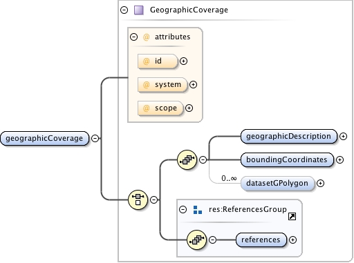
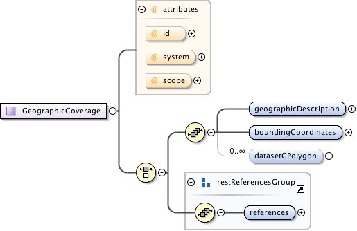
<doc:summary>Geographic coverage information.</doc:summary>
<doc:description>Geographic Coverage is a container for spatial
information about a a project, a resource, or an entity within a
resource.</doc:description>
<doc:example>Please see the individual sub-elements for specific
examples.</doc:example>
</xs:appinfo>
</xs:annotation>
<xs:choice>
<xs:sequence>
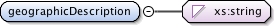
<xs:element name="geographicDescription" type="xs:string">
  <xs:annotation>
    <xs:appinfo>
      <doc:tooltip>Description of geographic extent</doc:tooltip>
      <doc:summary>Short description of the geographic areal domain of
              the data set.</doc:summary>
      <doc:description>A geographic extent description is especially
              important when the extent of the data set is not well described
              by the "Bounding_Rectangle_Coordinates", or in the case of data
              which are not specifically geospatial, to provide a geographic
              setting for the item being documented. Assuming the
              "Bounding_Rectangle_Coordinates" do not adequately describe the
              extent of the data set, the discrepancy can be identified and
              described in this data element. If the item being documented is
              not specifically geospatial, the "Bounding_Rectangle_Coordinates"
              can define a general polygon, such as a rectangle around a
              country, with this "Description_of_Geographic_Extent" element
              containing a disclaimer concerning the
              "Bounding_Rectangle_Coordinates" and/or further detail concerning
              the geographic area of concern for the item being documented. For
              example, a study of the diseases of salmon may not have a
              specific geographic extent associated with it, but the salmon
              involved in the study were collected in Washington and Oregon
              states, thus the "Bounding_Rectangle_Coordinates" might form a
              general rectangle around the states of Washington and Oregon, but
              the "Description_of_Geographic_Extent" might describe the fact
              that the extent within Washington and Oregon included only
              certain rivers within those states. This data element differs
              from the standard data element "Place_Keyword" in that it allows
              a free text description of the geographic extent, rather than
              just a list of words or phrases useful as an index of location
              names associated with the data set.</doc:description>
      <doc:example>Examples include, "Manistee River watershed",
              "extent of 7 1/2 minute quads containing any property belonging
              to Yellowstone National Park", or "ponds and reservoirs larger
              than 2 acres in Jefferson County, Colorado". This is especially
              important when the extent of the data set is not well described
              by the "Bounding_Rectangle_Coordinates".</doc:example>
    </xs:appinfo>
  </xs:annotation>
</xs:element>
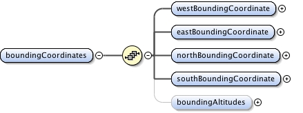
<xs:element name="boundingCoordinates">
<xs:annotation>
<xs:appinfo>
<doc:tooltip>Bounding coordinates</doc:tooltip>
<doc:summary>The 4 points (latitude and longitude pairs) that
define a bounding box on the earth's surface. To define a single
point, use the same point in both lat/lon pairs.</doc:summary>
<doc:description>The limits of coverage of a data set expressed
by latitude and longitude values in the order western-most,
eastern-most, northern-most, and southern-most. For data sets
that include a complete band of latitude around the earth, the
West Bounding Coordinate shall be assigned the value -180.0, and
the East Bounding Coordinate shall be assigned the value 180.0 If
your bounding area is a single point, use the same values for
northBoundingCoordinate and southBoundingCoordinate, as well as
the same value for westBoundingCoordinate and
eastBoundingCoordinate. This will define the same lat/lon pairs
since all four are required.</doc:description>
<doc:example>Please see the individual sub-fields for specific
examples.</doc:example>
</xs:appinfo>
</xs:annotation>
<xs:complexType>
<xs:sequence>
<xs:element name="westBoundingCoordinate" type="xs:string">
<xs:annotation>
<xs:appinfo>
<doc:tooltip>West bounding coordinate</doc:tooltip>
<doc:summary>Western-most coordinate of the limit of
coverage for a bounding box, expressed in degrees of
longitude.</doc:summary>
<doc:description>The west bounding coordinate field defines
the western-most point of the bounding box that is being
described. This longitude coordinate should be expressed in
decimal fractions of degrees. Whole degrees of longitude
shall be represented by a three-digit decimal number
ranging from 0 through 180. When a decimal fraction of a
degree is specified, it should be separated from the whole
number of degrees by a decimal point. Decimal fractions of
a degree may be expressed to the precision desired.
Longitudes east of the prime meridian shall be specified by
a plus sign (+), or by the absence of a minus sign (-),
preceding the three digits designating degrees of
longitude. Longitudes west of the meridian shall be
designated by minus sign (-) preceding the three digits
designating degrees. A point on the prime meridian shall be
assigned to the Eastern Hemisphere. A point on the 180th
meridian shall be assigned to the Western Hemisphere. One
exception to this last convention is permitted. For the
special condition of describing a band of latitude around
the earth, the East Bounding Coordinate data element shall
be assigned the value +180 (180) degrees.</doc:description>
<doc:example>'-118.25', '+25', '45.247'</doc:example>
</xs:appinfo>
</xs:annotation>
</xs:element>
<xs:element name="eastBoundingCoordinate" type="xs:string">
<xs:annotation>
<xs:appinfo>
<doc:tooltip>East bounding coordinate</doc:tooltip>
<doc:summary>Eastern-most coordinate of the limit of
coverage of a bounding box, expressed in degrees of
longitude.</doc:summary>
<doc:description>The east bounding coordinate field defines
the eastern-most point of the bounding box that is being
described. This longitude coordinate should be expressed in
decimal fractions of degrees. Whole degrees of longitude
shall be represented by a three-digit decimal number
ranging from 0 through 180. When a decimal fraction of a
degree is specified, it should be separated from the whole
number of degrees by a decimal point. Decimal fractions of
a degree may be expressed to the precision desired.
Longitudes east of the prime meridian shall be specified by
a plus sign (+), or by the absence of a minus sign (-),
preceding the three digits designating degrees of
longitude. Longitudes west of the meridian shall be
designated by minus sign (-) preceding the three digits
designating degrees. A point on the prime meridian shall be
assigned to the Eastern Hemisphere. A point on the 180th
meridian shall be assigned to the Western Hemisphere. One
exception to this last convention is permitted. For the
special condition of describing a band of latitude around
the earth, the East Bounding Coordinate data element shall
be assigned the value +180 (180) degrees.</doc:description>
<doc:example>'-118.25', '+25', '45.247'</doc:example>
</xs:appinfo>
</xs:annotation>
</xs:element>
<xs:element name="northBoundingCoordinate" type="xs:string">
<xs:annotation>
<xs:appinfo>
<doc:tooltip>North bounding coordinate</doc:tooltip>
<doc:summary>Northern-most coordinate of the limit of
coverage expressed in latitude.</doc:summary>
<doc:description>The north bounding coordinate field
defines the northern-most point of the bounding box that is
being described. This latitude coordinate should be
expressed in decimal fractions of degrees. Whole degrees of
latitude shall be represented by a two-digit decimal number
ranging from 0 through 90. When a decimal fraction of a
degree is specified, it shall be separated from the whole
number of degrees by a decimal point. Decimal fractions of
a degree may be expressed to the precision desired.
Latitudes north of the equator shall be specified by a plus
sign (+), or by the absence of a minus sign (-), preceding
the two digits designating degrees. Latitudes south of the
Equator shall be designated by a minus sign (-) preceding
the two digits designating degrees. A point on the Equator
shall be assigned to the Northern Hemisphere. Any spatial
address with a latitude of +90 (90) or -90 degrees will
specify the position at the North or South Pole,
respectively.</doc:description>
<doc:example>'-18.44', '+44.35', '86'</doc:example>
</xs:appinfo>
</xs:annotation>
</xs:element>
<xs:element name="southBoundingCoordinate" type="xs:string">
<xs:annotation>
<xs:appinfo>
<doc:tooltip>South bounding coordinate</doc:tooltip>
<doc:summary>Southern-most coordinate of the limit of
coverage expressed in latitude.</doc:summary>
<doc:description>The south bounding coordinate field
defines the southern-most point of the bounding box that is
being described. This latitude coordinate should be
expressed in decimal fractions of degrees. Whole degrees of
latitude shall be represented by a two-digit decimal number
ranging from 0 through 90. When a decimal fraction of a
degree is specified, it shall be separated from the whole
number of degrees by a decimal point. Decimal fractions of
a degree may be expressed to the precision desired.
Latitudes north of the equator shall be specified by a plus
sign (+), or by the absence of a minus sign (-), preceding
the two digits designating degrees. Latitudes south of the
Equator shall be designated by a minus sign (-) preceding
the two digits designating degrees. A point on the Equator
shall be assigned to the Northern Hemisphere. Any spatial
address with a latitude of +90 (90) or -90 degrees will
specify the position at the North or South Pole,
respectively.</doc:description>
<doc:example>'-18.44', '+44.35', '86'</doc:example>
</xs:appinfo>
</xs:annotation>
</xs:element>
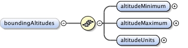
<xs:element name="boundingAltitudes" minOccurs="0">
<xs:annotation>
<xs:appinfo>
<doc:tooltip>Bounding altitudes</doc:tooltip>
<doc:summary>The limits of coverage of a data set expressed
by altitude.</doc:summary>
<doc:description>The bounding altitude field is intended to
contain altitudinal (elevation) measurements in relation to
the bounding box being described. It allows for minimum and
maximum altitude fields, as well as a field for the units
of measure. The combination of these fields provide the
vertical extent information for the bounding box. The units
should refer to an accepted datum as the
baseline.</doc:description>
<doc:example>Please see the individual sub-fields for
specific examples.</doc:example>
</xs:appinfo>
</xs:annotation>
<xs:complexType>
<xs:sequence>
<xs:element name="altitudeMinimum" type="xs:string">
<xs:annotation>
<xs:appinfo>
<doc:tooltip>Minimum altitude</doc:tooltip>
<doc:summary>The minimum altitude extent of
coverage.</doc:summary>
<doc:description>The minimum altitude extent of
coverage for the bounding box that is being
described. The minimum altitude should be in
reference to a known datum, which should be described
in the altitude units field.</doc:description>
<doc:example>'12', '100.6' (e.g meters above Mean
Lowest Low Water)</doc:example>
</xs:appinfo>
</xs:annotation>
</xs:element>
<xs:element name="altitudeMaximum" type="xs:string">
<xs:annotation>
<xs:appinfo>
<doc:tooltip>Maximum altitude</doc:tooltip>
<doc:summary>The maximum altitude extent of
coverage.</doc:summary>
<doc:description>The maximum altitude extent of
coverage for the bounding box that is being
described. The maximum altitude should be in
reference to a known datum, which should be described
in the altitude units field.</doc:description>
<doc:example>'12', '100.6' (e.g meters above Mean
Lowest Low Water)</doc:example>
</xs:appinfo>
</xs:annotation>
</xs:element>
<xs:element name="altitudeUnits" type="xs:string">
<xs:annotation>
<xs:appinfo>
<doc:tooltip>Units of altitude</doc:tooltip>
<doc:summary>Units in which altitude is
measured.</doc:summary>
<doc:description>Units in which altitude is measured.
This field should be in relation to a known datum
which is described in the units.</doc:description>
<doc:example>Meters (above Mean Lowest Low
Water)</doc:example>
</xs:appinfo>
</xs:annotation>
</xs:element>
</xs:sequence>
</xs:complexType>
</xs:element>
</xs:sequence>
</xs:complexType>
</xs:element>
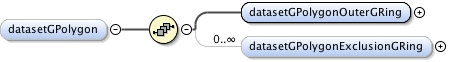
<xs:element name="datasetGPolygon" minOccurs="0" maxOccurs="unbounded">
<xs:annotation>
<xs:appinfo>
<doc:tooltip>Polygon data set</doc:tooltip>
<doc:summary>This construct creates a spatial ring with a
hollow center.</doc:summary>
<doc:description>This construct creates a spatial ring with a
hollow center. This doughnut shape is specified by the outer
ring (datasetGPolygonOuterRing) and the inner exclusion zone
(datasetGPolygonExclusionGRing) which can be thought of as the
hole in the center of a doughnut. This is useful for defining
areas such as the shores of a pond where you only want to specify
the shore excluding the pond itself.</doc:description>
<doc:example>Please see the individual sub-fields for specific
examples.</doc:example>
</xs:appinfo>
</xs:annotation>
<xs:complexType>
<xs:sequence>
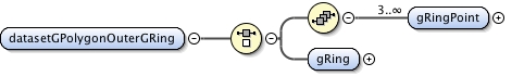
<xs:element name="datasetGPolygonOuterGRing">
<xs:annotation>
<xs:appinfo>
<doc:tooltip>Outer polygon</doc:tooltip>
<doc:summary>The outer containment loop of a datasetGPolygon.</doc:summary>
<doc:description>The outer containment loop of a
datasetGPolygon. This is the outer part of the doughnut
shape that encompasses the broadest area of coverage</doc:description>
</xs:appinfo>
</xs:annotation>
<xs:complexType>
<xs:choice>
<xs:sequence>
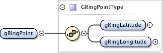
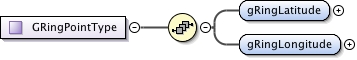
<xs:element name="gRingPoint" type="GRingPointType" minOccurs="3" maxOccurs="unbounded"/>
</xs:sequence>
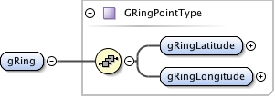
<xs:element name="gRing" type="GRingPointType"/>
</xs:choice>
</xs:complexType>
</xs:element>
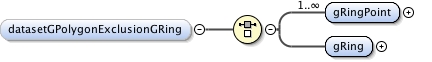
<xs:element name="datasetGPolygonExclusionGRing" minOccurs="0" maxOccurs="unbounded">
<xs:annotation>
<xs:appinfo>
<doc:tooltip>Exclusion polygon</doc:tooltip>
<doc:summary>Data Set G-Polygon Exclusion G-Ring, the
closed nonintersecting boundary of a void area (or hole in
an interior area).</doc:summary>
<doc:description>Data Set G-Polygon Exclusion G-Ring, the
closed nonintersecting boundary of a void area (or hole in
an interior area). This is the center of the doughnut
shape created by the datasetGPolygon.</doc:description>
</xs:appinfo>
</xs:annotation>
<xs:complexType>
<xs:choice>
<xs:element name="gRingPoint" type="GRingPointType" maxOccurs="unbounded"/>
<xs:element name="gRing" type="GRingPointType"/>
</xs:choice>
</xs:complexType>
</xs:element>
</xs:sequence>
</xs:complexType>
</xs:element>
</xs:sequence>
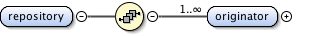
<xs:group ref="res:ReferencesGroup"/>
</xs:choice>
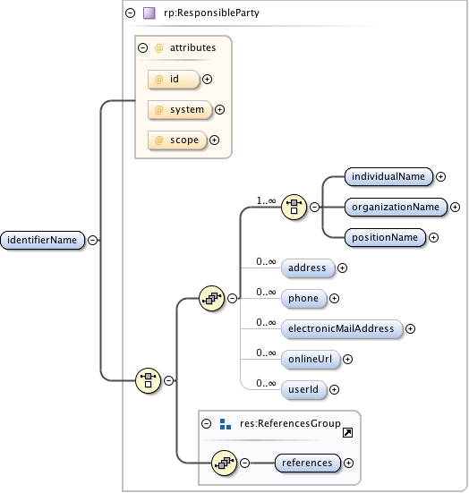
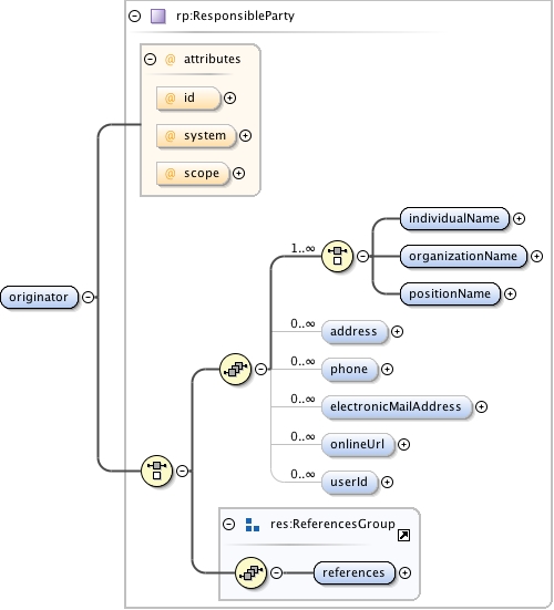
<xs:attribute name="id" type="res:IDType" use="optional"/>
<xs:attribute name="system" type="res:SystemType" use="optional"/>
<xs:attribute name="scope" type="res:ScopeType" use="optional" default="document"/>
</xs:complexType> |